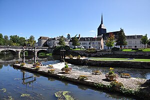
Romorantin-Lanthenay
Apparence
|
|||||
 | |||||
|
 Ansa | |||||
| |||||
| Awanek anayan | Fransa | ||||
| Division territoriale française (fr) | France métropolitaine (fr) | ||||
| Région française (fr) | Centre | ||||
| Agezdu afrensaw | Loir-et-Cher (fr) | ||||
| Arrondissement français (fr) | arrondissement de Romorantin-Lanthenay (fr) | ||||
| Ancien canton français (fr) | canton de Romorantin-Lanthenay-Nord (fr) | ||||
| Tamanaɣt n | |||||
| Imezdaɣ | |||||
| Teɣṛed | 18 377 (2022) | ||||
| • Tiineẓẓi n imezdaɣ | 405,54 imezdaɣen/km² | ||||
| Tarakalt | |||||
| Situé dans l'entité territoriale statistique (fr) |
aire d'attraction de Romorantin-Lanthenay (fr) unité urbaine de Romorantin-Lanthenay (fr) | ||||
| Tajumma | 45,315 km² | ||||
| Tezga-d ɣef yiri |
Sauldre (fr) | ||||
| Teflel | 84 m-121 m | ||||
| Tilisa yakked | |||||
| Amekzay uglim | |||||
| Code postal (fr) | 41200 | ||||
| Izṭi akudan | |||||
| Nniḍen | |||||
|
| |||||
| Tansa n web | romorantin.com | ||||
Romorantin-Lanthenay d tamdint n Fransa. D tamaneɣt n agezdu (département) n Loir-et-Cher. Zedɣen-tt 18 817 n yimezdaɣen.
| Wikimedia Commons tesɛa media ɣef Romorantin-Lanthenay. |


