
Tugna:Topographic map of Liberia-en.svg

Taille de cet aperçu PNG pour ce fichier SVG : 799 × 600 iferdisen n tugna. Tibuda nniḍen : 320 × 240 iferdisen n tugna | 640 × 480 iferdisen n tugna | 1 023 × 768 iferdisen n tugna | 1 280 × 961 iferdisen n tugna | 2 560 × 1 922 iferdisen n tugna | 3 148 × 2 363 iferdisen n tugna.
Afaylu aneṣli (Afaylu SVG, tabadut n 3 148 × 2 363 pixel, lqedd : 1,69 MB/MO)
Agzul
| Aglam |
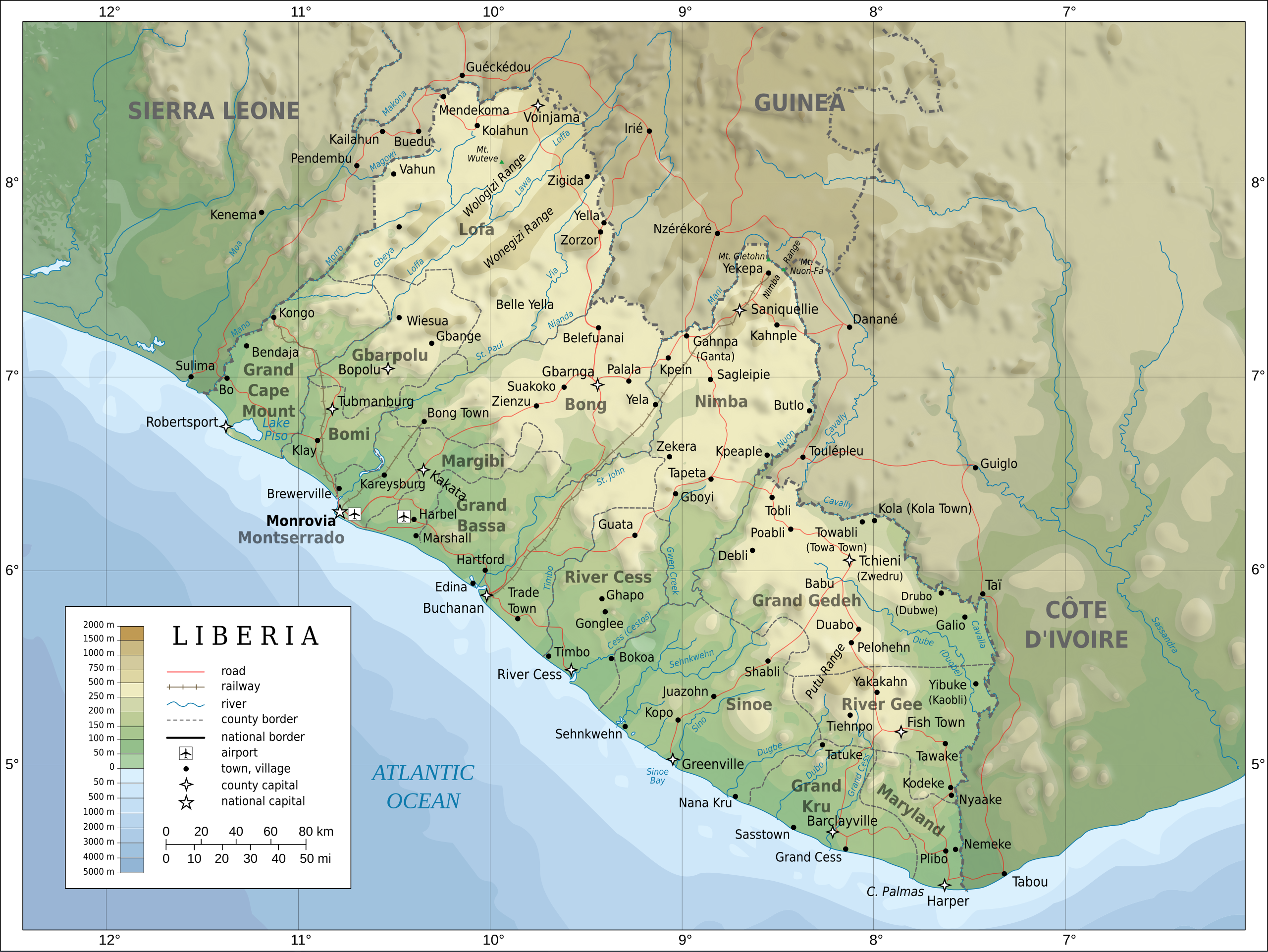
English: Topographic map of Liberia.
Français : Carte topographique du Liberia.
Suomi: Liberian topografinen kartta. |
| Azemz | |
| Aɣbalu |
Self-made in Inkscape. Boundaries, rivers, roads, railroads, and place names based on a public domain United Nations map (Image:Un-liberia.png). Topography based on public domain GLOBE data from NOAA (http://www.ngdc.noaa.gov/mgg/topo/gltiles.html). Relief shading is an embedded PNG raster, derived from the GLOBE data using Perl. Bathymetry from NGDC ETOPO2. |
| Ameskar | Oona Räisänen (Mysid) |
| Autres versions |
Derivative works of this file: Railways in liberia-de.svg
|


|
This SVG file contains embedded text that can be translated into your language, using any capable SVG editor, text editor or the SVG Translate tool. For more information see: About translating SVG files. |
Turagt
Moi, en tant que détenteur des droits d’auteur sur cette œuvre, je la publie sous les licences suivantes :

|
Ɣuṛ-k tasiregt akken ad tneɣleḍ, ad tzuzreḍ neɣ ad tesnifleḍ isemli-agi akken yella di tewtilin n GNU Free Documentation License lqem 1.2 neq yal lqem amaynut i d-yeffɣen sɣuṛ Free Software Foundation, s war abeddel di tgezmiyin, s war aḍris deg usebter amenzu n tdulineɣ s war aḍris deg usebter aneggaru n tduli. Amedya n turagt yedda deg tgezmi ittusemman GNU Free Documentation License. |
This file is licensed under the Creative Commons Attribution-Share Alike Attribution-Share Alike 4.0 International, 3.0 Unported, 2.5 Generic, 2.0 Generic and 1.0 Generic license.
- Ɣuṛ-k tilelli:
- i beṭṭu – akken ad tneɣleḍ, ad tzuzreḍ neɣ ad tebḍuḍ amahil-agi
- i uṣeggem – i uṣeggem n umahil
- Ddaw n tiwtilin-agi:
- bab – Yessefk ad d-bedreḍ isem n umeskar aneṣli s wudem yettwammlen sɣuṛ ameskar n umahil neɣ bab n izerfan i k-imudden tasiregt (mačči s wudem yemmalen am akken yettmuddu-yak afus neɣ yeqbel aseqdec-it n umahil).
- bḍut akken yella – Ma tbeddleḍ, teskelteḍ, neɣ tebniḍ ɣef umahil-agi, yessefk ad tezzuzreḍ amahil i d-yeffɣen ɣas ddaw n turagt-nni neɣ turagt icuban ɣuṛ-s.
Tzemreḍ ad ferneḍ yiwet seg turagin-agi.
Amazray n ufaylu
Senned ɣef yiwen azmez d usrag iwakken ad ẓṛeḍ afaylu aken yella deg imir nni.
| Azemz/Ssaɛa | Aqmamaḍ | Iseggiwen | Amseqdac | Awennit | |
|---|---|---|---|---|---|
| Lux a | 31 Yulyu 2010 à 20:08 | | 3 148 × 2 363 (1,69 MB/MO) | Mysid | remove the false "dropoff" from land to sea in shading |
| 31 Yulyu 2010 à 20:02 |  | 3 148 × 2 363 (1,69 MB/MO) | Mysid | fixed a couple of symbols + clipped the shading layer | |
| 19 Yulyu 2010 à 10:49 |  | 3 148 × 2 363 (2,64 MB/MO) | Mysid | argh, forgot to update legend box | |
| 19 Yulyu 2010 à 10:41 |  | 3 148 × 2 363 (2,64 MB/MO) | Mysid | revised for consistency with my other maps | |
| 25 Mayyu 2008 à 12:46 |  | 3 148 × 2 363 (2,87 MB/MO) | Mysid | border in image; layers in XML | |
| 12 Mayyu 2008 à 18:34 |  | 3 037 × 2 257 (2,82 MB/MO) | Mysid | adding lakes, airports, legends | |
| 12 Mayyu 2008 à 16:44 |  | 3 037 × 2 257 (2,81 MB/MO) | Mysid | == {{int:filedesc}} == {{Information |Description= {{en|Topographic map of Liberia.}} {{fr|Carte topographique du Liberia.}} {{fi|Liberian topografinen kartta.}} |Source=Self-made in Inkscape.<br/>Boundaries |
Aseqdec n ufaylu
Ulaḥedd seg isebtar sɛan azday ar afaylu-agi.
Aseqdec n ufaylu amatu
Iwikiyen-agi-nniḍen seqdacen afaylu-agi:
- Aseqdec ɣef ar.wikipedia.org
- Aseqdec ɣef az.wikipedia.org
- Aseqdec ɣef bcl.wikipedia.org
- Aseqdec ɣef be-tarask.wikipedia.org
- Aseqdec ɣef be.wikipedia.org
- Aseqdec ɣef bn.wikipedia.org
- Aseqdec ɣef ca.wikipedia.org
- Aseqdec ɣef ckb.wikipedia.org
- Aseqdec ɣef de.wikipedia.org
- Aseqdec ɣef el.wikipedia.org
- Aseqdec ɣef en.wikipedia.org
- Aseqdec ɣef eu.wikipedia.org
- Aseqdec ɣef fa.wikipedia.org
- Aseqdec ɣef fi.wikipedia.org
- Aseqdec ɣef fr.wikipedia.org
- Aseqdec ɣef hr.wiktionary.org
- Aseqdec ɣef hu.wikipedia.org
- Aseqdec ɣef hy.wikipedia.org
- Aseqdec ɣef id.wikipedia.org
- Aseqdec ɣef io.wikipedia.org
- Aseqdec ɣef is.wikipedia.org
- Aseqdec ɣef it.wikipedia.org
- Aseqdec ɣef ka.wikipedia.org
- Aseqdec ɣef lt.wikipedia.org
- Aseqdec ɣef mzn.wikipedia.org
- Aseqdec ɣef nds.wikipedia.org
- Aseqdec ɣef nl.wikipedia.org
- Aseqdec ɣef pl.wikipedia.org
- Aseqdec ɣef ps.wikipedia.org
Wali l’utilisation globale n ufaylu-agi.