
Tugna:Satellite image of Antigua And Barbuda in September 2002.jpg
Ulac tabadut tameqqṛant i yellan.
Satellite_image_of_Antigua_And_Barbuda_in_September_2002.jpg (311 × 372 pixel, tiddi n ufaylu: 16 KB/KO, anaw n MIME: image/jpeg)
Agzul
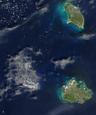
| Aglam | Cropped satellite image, showing the three islands of Antigua And Barbuda. |
| Azemz | |
| Aɣbalu | Cropped from: http://visibleearth.nasa.gov/view_rec.php?id=4342 |
| Ameskar | Jacques Descloitres, MODIS Rapid Response Team, NASA/GSFC |
Turagt
| Ce fichier provient de la NASA. Sauf exception, les documents créés par la NASA ne sont pas soumis à copyright. Pour plus d'informations, voir la politique de copyright de la NASA. | ||
 |
Attention :
|
| Annotations | This image is annotated: View the annotations at Commons |
Amazray n ufaylu
Senned ɣef yiwen azmez d usrag iwakken ad ẓṛeḍ afaylu aken yella deg imir nni.
| Azemz/Ssaɛa | Aqmamaḍ | Iseggiwen | Amseqdac | Awennit | |
|---|---|---|---|---|---|
| Lux a | 18 Duǧember 2004 à 14:26 | | 311 × 372 (16 KB/KO) | Hautala | {{PD-USGov-NASA}} Cropped satellite image, showing the three islands of Antigua And Barbuda. Original image taken from NASA's Visible Earth http://visibleearth.nasa.gov/cgi-bin/viewrecord?21888 |
Aseqdec n ufaylu
Asebter agi teseqdac afaylu agi :
Aseqdec n ufaylu amatu
Iwikiyen-agi-nniḍen seqdacen afaylu-agi:
- Aseqdec ɣef af.wikipedia.org
- Aseqdec ɣef arz.wikipedia.org
- Aseqdec ɣef ast.wikipedia.org
- Aseqdec ɣef azb.wikipedia.org
- Aseqdec ɣef ca.wikipedia.org
- Aseqdec ɣef cy.wikipedia.org
- Aseqdec ɣef de.wikivoyage.org
- Aseqdec ɣef diq.wikipedia.org
- Aseqdec ɣef el.wikipedia.org
- Aseqdec ɣef en.wikipedia.org
- Aseqdec ɣef eo.wikipedia.org
- Aseqdec ɣef fa.wikipedia.org
- Aseqdec ɣef fi.wikipedia.org
- Aseqdec ɣef fr.wikipedia.org
- Aseqdec ɣef ga.wikipedia.org
- Aseqdec ɣef gd.wikipedia.org
- Aseqdec ɣef gl.wikipedia.org
- Aseqdec ɣef ha.wikipedia.org
- Aseqdec ɣef hu.wikipedia.org
- Aseqdec ɣef ia.wikipedia.org
- Aseqdec ɣef io.wikipedia.org
- Aseqdec ɣef ja.wikipedia.org
- Aseqdec ɣef nl.wikipedia.org
- Aseqdec ɣef pcd.wikipedia.org
- Aseqdec ɣef pl.wikipedia.org
- Aseqdec ɣef pl.wiktionary.org
- Aseqdec ɣef ru.wikipedia.org
- Aseqdec ɣef sq.wikipedia.org
- Aseqdec ɣef uk.wikipedia.org
- Aseqdec ɣef vec.wikipedia.org
- Aseqdec ɣef www.wikidata.org