
Tugna:North Sea map-en.png

Tiddi n azaraskan agi : 479 × 600 iferdisen n tugna. Tibuda nniḍen : 192 × 240 iferdisen n tugna | 383 × 480 iferdisen n tugna | 613 × 768 iferdisen n tugna | 817 × 1 024 iferdisen n tugna | 2 475 × 3 100 iferdisen n tugna.
Afaylu aneṣli (2 475 × 3 100 pixel, tiddi n ufaylu: 3,8 MB/MO, anaw n MIME: image/png)
P
Agzul
| Aglam | |
| Azemz | |
| Aɣbalu |
Amahil udmawan using en:GRASS GIS, en:Inkscape and en:GIMP. Data sources:
Map Projection: Universal Transverse Mercator Typeface: Gentium Book Basic from SIL International |
| Ameskar | Halava |
| Autres versions |
  |
Turagt
Moi, en tant que détenteur des droits d’auteur sur cette œuvre, je la publie sous les licences suivantes :
Afaylu-agi yella ddaw n tewtilin n turagt Creative Commons Attribution-Share Alike 3.0 Unported.
- Ɣuṛ-k tilelli:
- i beṭṭu – akken ad tneɣleḍ, ad tzuzreḍ neɣ ad tebḍuḍ amahil-agi
- i uṣeggem – i uṣeggem n umahil
- Ddaw n tiwtilin-agi:
- bab – Yessefk ad d-bedreḍ isem n umeskar aneṣli s wudem yettwammlen sɣuṛ ameskar n umahil neɣ bab n izerfan i k-imudden tasiregt (mačči s wudem yemmalen am akken yettmuddu-yak afus neɣ yeqbel aseqdec-it n umahil).
- bḍut akken yella – Ma tbeddleḍ, teskelteḍ, neɣ tebniḍ ɣef umahil-agi, yessefk ad tezzuzreḍ amahil i d-yeffɣen ɣas ddaw n turagt-nni neɣ turagt icuban ɣuṛ-s.

|
Ɣuṛ-k tasiregt akken ad tneɣleḍ, ad tzuzreḍ neɣ ad tesnifleḍ isemli-agi akken yella di tewtilin n GNU Free Documentation License lqem 1.2 neq yal lqem amaynut i d-yeffɣen sɣuṛ Free Software Foundation, s war abeddel di tgezmiyin, s war aḍris deg usebter amenzu n tdulineɣ s war aḍris deg usebter aneggaru n tduli. Amedya n turagt yedda deg tgezmi ittusemman GNU Free Documentation License. |
Tzemreḍ ad ferneḍ yiwet seg turagin-agi.
| Annotations | This image is annotated: View the annotations at Commons |
Amazray n ufaylu
Senned ɣef yiwen azmez d usrag iwakken ad ẓṛeḍ afaylu aken yella deg imir nni.
| Azemz/Ssaɛa | Aqmamaḍ | Iseggiwen | Amseqdac | Awennit | |
|---|---|---|---|---|---|
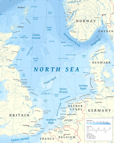
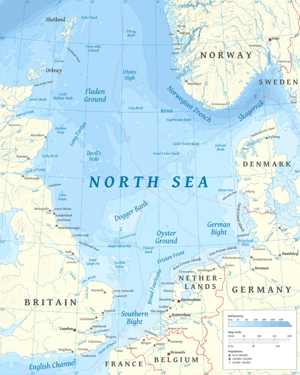
| Lux a | 5 Meɣres 2015 à 17:23 | | 2 475 × 3 100 (3,8 MB/MO) | Tandru7 | {{Information |Description=Map of the North Sea |Source=Wiki Commons |Date=3/5/15 |Author= |Permission= |other_versions= }} |
| 15 Tuber 2010 à 14:48 |  | 2 475 × 3 100 (3,8 MB/MO) | Halava | New place names | |
| 12 Tuber 2010 à 17:34 |  | 2 475 × 3 100 (3,79 MB/MO) | Halava | Some corrections; several new place names | |
| 12 Tuber 2010 à 11:02 |  | 2 475 × 3 100 (3,78 MB/MO) | Halava | Minor corrections; improved legibility; Horns Rev | |
| 10 Tuber 2010 à 08:09 |  | 2 475 × 3 100 (3,72 MB/MO) | Halava | Exclusive economic zones; Heligoland | |
| 9 Tuber 2010 à 09:26 |  | 2 475 × 3 100 (3,64 MB/MO) | Halava | Lindisfarne; Norfolk Banks instead of Wells Bank | |
| 8 Tuber 2010 à 20:27 |  | 2 475 × 3 100 (3,63 MB/MO) | Halava | Outlined Dogger Bank, fixed a typo | |
| 8 Tuber 2010 à 17:04 |  | 2 475 × 3 100 (3,61 MB/MO) | Halava | Several improvements | |
| 6 Tuber 2010 à 10:52 |  | 2 475 × 3 100 (3,37 MB/MO) | Halava | Fixed two typos, switched color model to RGB | |
| 6 Tuber 2010 à 10:09 |  | 2 475 × 3 100 (2,57 MB/MO) | Halava | {{Information |Description={{en|1=Map of the North Sea.}} |Source={{own}} using GRASS GIS, Inkscape and GIMP. Data sources: * Elevation and bathymetry data from NGDC ETOPO1 * Coastlines, rivers and borders from NGDC World Data Bank II * Cities from OpenS |
Aseqdec n ufaylu
Asebter agi teseqdac afaylu agi :
Aseqdec n ufaylu amatu
Iwikiyen-agi-nniḍen seqdacen afaylu-agi:
- Aseqdec ɣef af.wikipedia.org
- Aseqdec ɣef ar.wikipedia.org
- Aseqdec ɣef arz.wikipedia.org
- Aseqdec ɣef ast.wikipedia.org
- Aseqdec ɣef ba.wikipedia.org
- Aseqdec ɣef be-tarask.wikipedia.org
- Aseqdec ɣef bg.wikipedia.org
- Aseqdec ɣef br.wikipedia.org
- Aseqdec ɣef ca.wikipedia.org
- Aseqdec ɣef cs.wikipedia.org
- Aseqdec ɣef cy.wikipedia.org
- Aseqdec ɣef de.wikipedia.org
- Aseqdec ɣef de.wikivoyage.org
- Aseqdec ɣef el.wikipedia.org
- Aseqdec ɣef en.wikipedia.org
- North Sea
- Skagerrak
- SMS Lützow
- HMS King Edward VII
- HMS Marlborough (1912)
- HMS Emperor of India
- HMS Africa (1905)
- Horns Rev
- HMS Britannia (1904)
- Silverpit crater
- Broad Fourteens
- Dogger Bank
- Long Forties
- HMS Hibernia (1905)
- Fisher Bank
- Norwegian trench
- Silver Pit
- Wikipedia:Userboxes/Location
- Operation Wikinger
- HMS Commonwealth
- Northern Patrol
- Raid on Scarborough, Hartlepool and Whitby
- HMS Hindustan (1903)
- User:Buaidh
- Southern Bight
- History of the North Sea
- First Ostend Raid
- Bombardment of Yarmouth and Lowestoft
Wali l’utilisation globale n ufaylu-agi.