
Tugna:Nigeria (orthographic projection).svg

Taille de cet aperçu PNG pour ce fichier SVG : 553 × 553 iferdisen n tugna. Tibuda nniḍen : 240 × 240 iferdisen n tugna | 480 × 480 iferdisen n tugna | 768 × 768 iferdisen n tugna | 1 024 × 1 024 iferdisen n tugna | 2 048 × 2 048 iferdisen n tugna.
Afaylu aneṣli (Afaylu SVG, tabadut n 553 × 553 pixel, lqedd : 218 KB/KO)
Agzul
| Aglam |
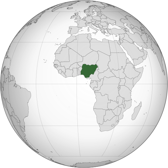
English: Orthographic map of Nigeria |
| Azemz | |
| Aɣbalu | Amahil udmawan |
| Ameskar | Ukabia |
| Autres versions |
.svg) |
.svg)
.svg)
.svg)
.svg)
.svg)
.svg)
.svg)
.svg)
.svg)
.svg)
.svg)
.svg)
.svg)
.svg)
.svg)
.svg)
.svg)
.svg)
.svg)
.svg)
.svg)
.svg)
.svg)
.svg)
.svg)
.svg)
.svg)
.svg)
.svg)
.svg)
.svg)
.svg)
.svg)
.svg)
.svg)
.svg)
.svg)
.svg)
.svg)
.svg)
.svg)
.svg)
.svg)
.svg)
.svg)
.svg)
.svg)
.svg)
.svg)
.svg)
.svg)
.svg)
.svg)
.svg)
.svg)
.svg)
.svg)
.svg)
.svg)
.svg)
.svg)
.svg)
.svg)
.svg)
.svg)
.svg)
.svg)
.svg)
.svg)
.svg)
.svg)
.svg)
.svg)

.svg)

.svg)

.svg)
.svg)
.svg)
.svg)
.svg)
.svg)
.svg)


.svg)
.svg)
.svg)
.svg)
.svg)
.svg)
.svg)

.svg)
.svg)
.svg)
.svg)
.svg)
.svg)
.svg)
.svg)
.svg)

.svg)
.svg)
.svg)
.svg)
.svg)
.svg)
.svg)
_without_national_boundaries.svg)
.svg)
.svg)
.svg)
.svg)
.svg)
.svg)

.svg)
.svg)
.png)
.svg)
.svg)
.svg)
.svg)

.svg)
.svg)
.svg)
.svg)
.svg)
.svg)
.svg)
.svg)
.svg)
.svg)
.svg)

.svg)
.svg)
.svg)
.svg)
.svg)
.svg)
.svg)
.svg)
.svg)

.svg)
.svg)

.svg)
.svg)
.svg)
.svg)
.svg)
.svg)
.svg)
.svg)
.svg)
.svg)
.svg)
.svg)
.svg)
.svg)
.svg)
.svg)
.svg)
.svg)
.svg)
.svg)
.svg)
.svg)
.svg)
.svg)
.svg)
.svg)
.svg)
_-_Crimea_disputed.svg)
.svg)
.svg)
.svg)
.svg)
.svg)
.svg)
.svg)
.svg)
.svg)
.svg)
.svg)
_political.svg)
.svg)
.svg)
.svg)
.svg)
_-_Crimea_disputed_-_no_borders.svg)
.svg)
.svg)
.svg)
.svg)
.svg)
.svg)
.svg)
.svg)
.svg)
.svg)
.svg)

.svg)
.svg)
.svg)

.png)
.svg)
.svg)
.svg)
.svg)
.svg)
.svg)
.svg)
.svg)
.svg)
.svg)
.svg)
.svg)
.svg)
.svg)
.svg)
.svg)
.svg)
.svg)
.svg)
.svg)
.svg)
.svg)
.svg)
.svg)
.svg)
.svg)
.svg)
.svg)
.svg)
.svg)
.svg)
.svg)
.svg)
.svg)
.png)
.svg)
.svg)
.svg)
_(orthographic_projection).png)
.svg)
W3C-validity not checked.
Turagt
Moi, en tant que détenteur des droits d’auteur sur cette œuvre, je la publie sous les licences suivantes :
Afaylu-agi yella ddaw n tewtilin n turagt Creative Commons Attribution-Share Alike 3.0 Unported.
- Ɣuṛ-k tilelli:
- i beṭṭu – akken ad tneɣleḍ, ad tzuzreḍ neɣ ad tebḍuḍ amahil-agi
- i uṣeggem – i uṣeggem n umahil
- Ddaw n tiwtilin-agi:
- bab – Yessefk ad d-bedreḍ isem n umeskar aneṣli s wudem yettwammlen sɣuṛ ameskar n umahil neɣ bab n izerfan i k-imudden tasiregt (mačči s wudem yemmalen am akken yettmuddu-yak afus neɣ yeqbel aseqdec-it n umahil).
- bḍut akken yella – Ma tbeddleḍ, teskelteḍ, neɣ tebniḍ ɣef umahil-agi, yessefk ad tezzuzreḍ amahil i d-yeffɣen ɣas ddaw n turagt-nni neɣ turagt icuban ɣuṛ-s.

|
Ɣuṛ-k tasiregt akken ad tneɣleḍ, ad tzuzreḍ neɣ ad tesnifleḍ isemli-agi akken yella di tewtilin n GNU Free Documentation License lqem 1.2 neq yal lqem amaynut i d-yeffɣen sɣuṛ Free Software Foundation, s war abeddel di tgezmiyin, s war aḍris deg usebter amenzu n tdulineɣ s war aḍris deg usebter aneggaru n tduli. Amedya n turagt yedda deg tgezmi ittusemman GNU Free Documentation License. |
Tzemreḍ ad ferneḍ yiwet seg turagin-agi.
Amazray n ufaylu
Senned ɣef yiwen azmez d usrag iwakken ad ẓṛeḍ afaylu aken yella deg imir nni.
| Azemz/Ssaɛa | Aqmamaḍ | Iseggiwen | Amseqdac | Awennit | |
|---|---|---|---|---|---|
| Lux a | 16 Meɣres 2015 à 23:52 | | 553 × 553 (218 KB/KO) | Flappiefh | Removed Somaliland and Kosovo. Separated Western Sahara and Morroco. |
| 30 Yulyu 2013 à 17:49 |  | 553 × 553 (217 KB/KO) | Flappiefh | South Sudan added. Map made with gringer's Perlshaper tool. | |
| 1 Yulyu 2013 à 04:53 |  | 550 × 550 (183 KB/KO) | Citypeek | Valid SVG now. | |
| 20 Fuṛaṛ 2010 à 19:20 |  | 550 × 550 (144 KB/KO) | Ukabia | Changed the grey globe to gradient (Please fix to match all other orthographic project gradients if you can) and removed transparency. | |
| 20 Fuṛaṛ 2010 à 19:06 |  | 550 × 550 (144 KB/KO) | Ukabia | Transparency removed | |
| 20 Fuṛaṛ 2010 à 19:03 |  | 550 × 550 (143 KB/KO) | Ukabia | Changed the grey globe to gradient (Please fix to match all other orthographic project gradients if you can) | |
| 20 Fuṛaṛ 2010 à 18:27 |  | 550 × 550 (144 KB/KO) | Ukabia | {{Information |Description={{en|1=Orthographic map of Africa}} |Source=*File:Africa_(orthographic_projection).svg |Date=2010-02-20 18:27 (UTC) |Author=*File:Africa_(orthographic_projection).svg: Martin23230 *derivative wor |
.svg)
Aseqdec n ufaylu
Asebter agi teseqdac afaylu agi :
Aseqdec n ufaylu amatu
Iwikiyen-agi-nniḍen seqdacen afaylu-agi:
- Aseqdec ɣef ady.wikipedia.org
- Aseqdec ɣef ami.wikipedia.org
- Aseqdec ɣef ar.wikipedia.org
- نيجيريا
- بوابة:العالم الإسلامي/دولة مختارة/54
- معاملة المثليين في نيجيريا
- مستخدم:جار الله/قائمة صور مقالات العلاقات الثنائية
- العلاقات الأمريكية النيجيرية
- العلاقات الأنغولية النيجيرية
- العلاقات الكورية الجنوبية النيجيرية
- العلاقات الإريترية النيجيرية
- العلاقات السويسرية النيجيرية
- العلاقات الألمانية النيجيرية
- العلاقات الليختنشتانية النيجيرية
- العلاقات البوليفية النيجيرية
- العلاقات الموزمبيقية النيجيرية
- العلاقات الألبانية النيجيرية
- العلاقات البلجيكية النيجيرية
- العلاقات الإثيوبية النيجيرية
- العلاقات البيلاروسية النيجيرية
- العلاقات الطاجيكستانية النيجيرية
- العلاقات الروسية النيجيرية
- العلاقات الرومانية النيجيرية
- العلاقات الأرجنتينية النيجيرية
- العلاقات الغامبية النيجيرية
- العلاقات القبرصية النيجيرية
- العلاقات السيراليونية النيجيرية
- العلاقات النيبالية النيجيرية
- العلاقات الليبيرية النيجيرية
- العلاقات التشيكية النيجيرية
- العلاقات الميانمارية النيجيرية
- العلاقات الكندية النيجيرية
- العلاقات العراقية النيجيرية
- العلاقات البريطانية النيجيرية
- العلاقات الكوبية النيجيرية
- العلاقات الكورية الشمالية النيجيرية
- العلاقات الكوستاريكية النيجيرية
- العلاقات الكولومبية النيجيرية
- العلاقات الكيريباتية النيجيرية
- العلاقات الكينية النيجيرية
- العلاقات اللاتفية النيجيرية
- العلاقات اللاوسية النيجيرية
- العلاقات اللبنانية النيجيرية
- العلاقات اللوكسمبورغية النيجيرية
- العلاقات الليبية النيجيرية
- العلاقات الليتوانية النيجيرية
- العلاقات الليسوتوية النيجيرية
- العلاقات المالاوية النيجيرية
- العلاقات المالطية النيجيرية
- العلاقات المالية النيجيرية
- العلاقات الماليزية النيجيرية
Wali l’utilisation globale n ufaylu-agi.
.svg)
.svg)