Tugna:Hawaje.jpg

Le contenu de la page n’est pas pris en charge dans d’autres langues.
Si Wikipedia, tasanayt tilellit.

Afaylu aneṣli(3 600 × 2 800 pixel, tiddi n ufaylu: 1,16 MB/MO, anaw n MIME: image/jpeg)

Afaylu agi yusad seg : Wikimedia Commons. Ahat yeseqdec deg isenfaṛen nniḍen. Aglam-is ɣef asebter n aglam ye beqqeḍ ddaw-agi.

Agzul

Aglam
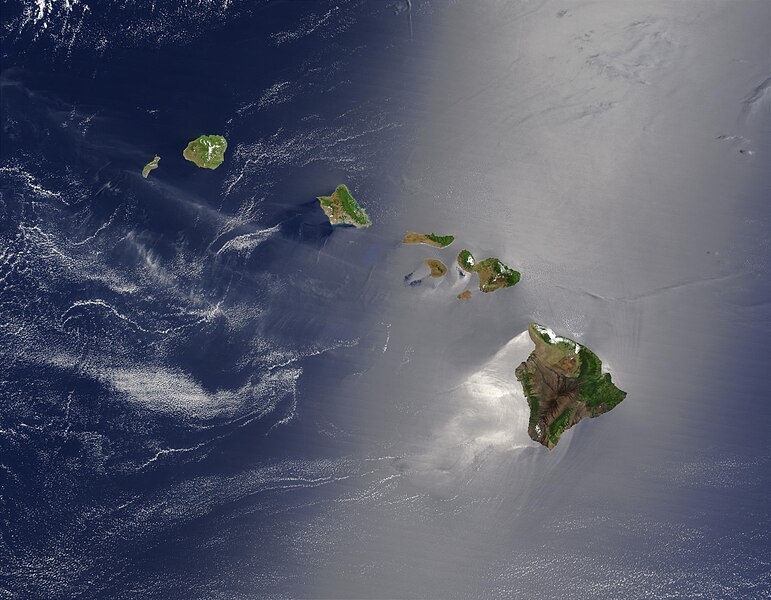
English: Satellite view of Hawaii archipellago (USA).

Original description from NASA:

"A silver swath of sunglint surrounds half of the Hawaiian islands in this true-color Terra MODIS image acquired on May 27, 2003. Sunglint reveals turbulence in the surface waters of the Pacific Ocean. If the surface of the water was as smooth as a perfect mirror, we would see the circle of the Sun as a perfect reflection. But because the surface of the water is ruffled with waves, each wave acts like a mirror and the Sun’s reflection gets softened into a broader silver swath, called the sunglint region.

"In this scene, the winds ruffling the water surface around the Hawaiian Islands create varying patterns, leaving some areas calmer than others. Southwest of Hawaii and Maui, on their leeward sides, calmer waters are indicated by brighter silver coloration. Conversely, notice how most of the vegetation on the Hawaiian Islands grows on their northeastern, or windward, sides.

"From lower right to upper left, the “Big Island” (Hawaii), Maui, Kahoolawe, Lanai, Molokai, Oahu, Kauai, and Niihau islands all make up the state of Hawaii, which lies more than 2,000 miles from any other part of the United States. The small red dot on the Big Island’s southeastern side marks a hot spot on Kilauea Volcano’s southern flank. Kilauea has been erupting almost continuously since January 1983, and is one of the world’s best studied volcanoes."
Français : Vue satellite de l'archipel d'Hawaï (États-Unis).
Azemz
Aɣbalu NASA. Image courtesy Jacques Descloitres, MODIS Land Rapid Response Team at NASA GSFC. (IotD Date: 2003-06-03. IotD ID: 15304)
Ameskar Jacques Descloitres
Autres versions
Modified version
Cette image a été retouchée, ce qui signifie qu'elle a été modifiée par ordinateur et est différente de l'image d'origine. Liste des modifications : cloned out and healed little red line on the big island. L'image d'origine se trouve ici : Hawaje.jpg. Modifications effectuées par IdLoveOne.

Derivative works

Derivative works of this file:  Hawaje-NoRedLine.jpg

Turagt

Public domain Ce fichier provient de la NASA. Sauf exception, les documents créés par la NASA ne sont pas soumis à copyright. Pour plus d'informations, voir la politique de copyright de la NASA.
Attention :

Légendes

Ajoutez en une ligne la description de ce que représente ce fichier

Éléments décrits dans ce fichier

igellem

Amazray n ufaylu

Senned ɣef yiwen azmez d usrag iwakken ad ẓṛeḍ afaylu aken yella deg imir nni.

Azemz/SsaɛaAqmamaḍIseggiwenAmseqdacAwennit
Lux a26 Tuber 2005 à 18:19Tugna tamectuḥt i lqem n 26 Tuber 2005 à 18:193 600 × 2 800 (1,16 MB/MO)PalladinusHawaii Islands

Ulaḥedd seg isebtar sɛan azday ar afaylu-agi.

Aseqdec n ufaylu amatu

Iwikiyen-agi-nniḍen seqdacen afaylu-agi:

Adferisefka