
Tugna:Djibouti location map.svg

Taille de cet aperçu PNG pour ce fichier SVG : 599 × 600 iferdisen n tugna. Tibuda nniḍen : 240 × 240 iferdisen n tugna | 480 × 480 iferdisen n tugna | 767 × 768 iferdisen n tugna | 1 023 × 1 024 iferdisen n tugna | 2 046 × 2 048 iferdisen n tugna | 1 040 × 1 041 iferdisen n tugna.
Afaylu aneṣli (Afaylu SVG, tabadut n 1 040 × 1 041 pixel, lqedd : 134 KB/KO)
Agzul
| Aglam |
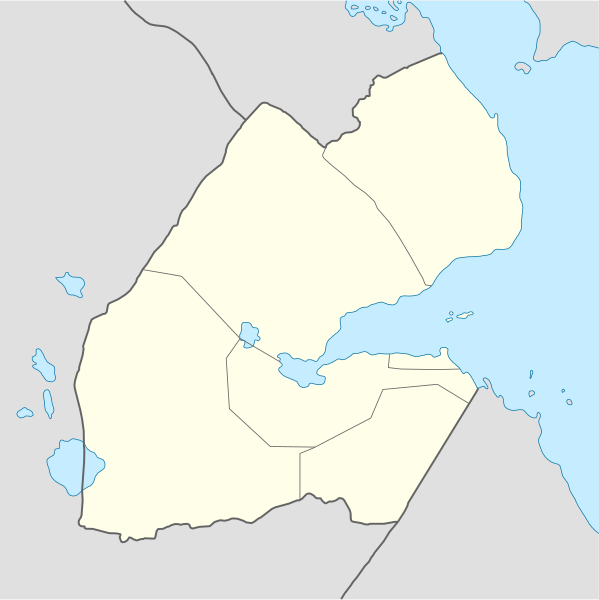
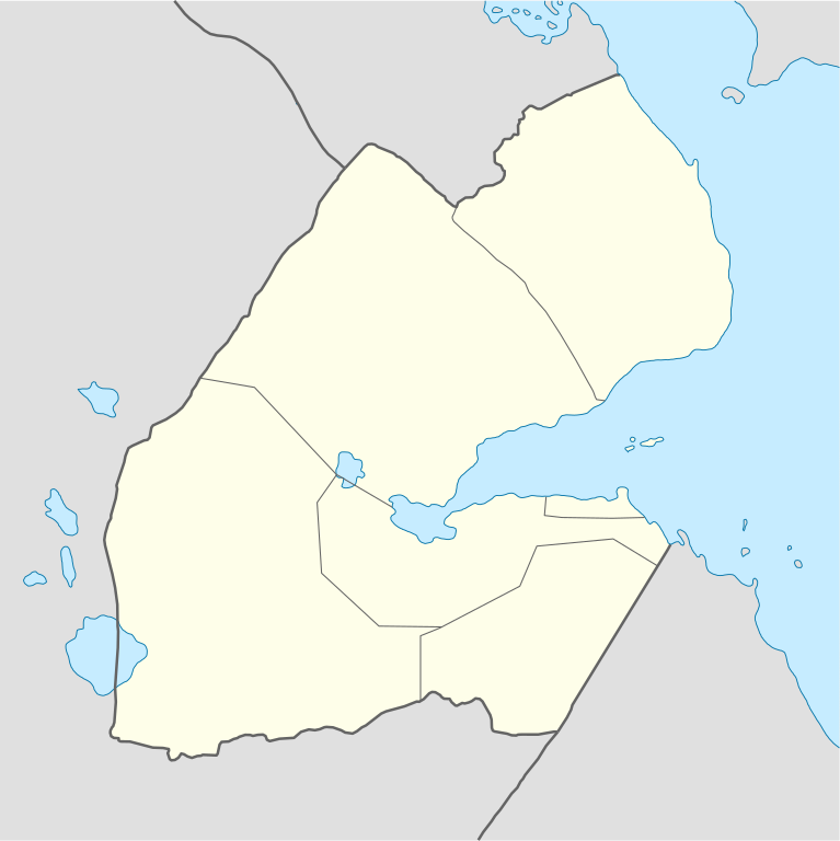
Deutsch: Positionskarte von Dschibuti
Quadratische Plattkarte. Geographische Begrenzung der Karte:
English: Location map of Djibouti
Equirectangular projection. Geographic limits of the map:
|
| Azemz | |
| Aɣbalu |
own work, using
|
| Ameskar | NordNordWest |
| Autres versions |
|


|
Cette carte a été créée ou améliorée dans le Kartenwerkstatt (Atelier cartographique allemand). Vous pouvez également y proposer des cartes à améliorer.
|
Turagt
Moi, en tant que détenteur des droits d’auteur sur cette œuvre, je la publie sous les licences suivantes :

|
Ɣuṛ-k tasiregt akken ad tneɣleḍ, ad tzuzreḍ neɣ ad tesnifleḍ isemli-agi akken yella di tewtilin n GNU Free Documentation License lqem 1.2 neq yal lqem amaynut i d-yeffɣen sɣuṛ Free Software Foundation, s war abeddel di tgezmiyin, s war aḍris deg usebter amenzu n tdulineɣ s war aḍris deg usebter aneggaru n tduli. Amedya n turagt yedda deg tgezmi ittusemman GNU Free Documentation License. |
Afaylu-agi yella ddaw n tewtilin n turagt Creative Commons Attribution-Share Alike 3.0 Unported.
- Ɣuṛ-k tilelli:
- i beṭṭu – akken ad tneɣleḍ, ad tzuzreḍ neɣ ad tebḍuḍ amahil-agi
- i uṣeggem – i uṣeggem n umahil
- Ddaw n tiwtilin-agi:
- bab – Yessefk ad d-bedreḍ isem n umeskar aneṣli s wudem yettwammlen sɣuṛ ameskar n umahil neɣ bab n izerfan i k-imudden tasiregt (mačči s wudem yemmalen am akken yettmuddu-yak afus neɣ yeqbel aseqdec-it n umahil).
- bḍut akken yella – Ma tbeddleḍ, teskelteḍ, neɣ tebniḍ ɣef umahil-agi, yessefk ad tezzuzreḍ amahil i d-yeffɣen ɣas ddaw n turagt-nni neɣ turagt icuban ɣuṛ-s.
Tzemreḍ ad ferneḍ yiwet seg turagin-agi.
Amazray n ufaylu
Senned ɣef yiwen azmez d usrag iwakken ad ẓṛeḍ afaylu aken yella deg imir nni.
| Azemz/Ssaɛa | Aqmamaḍ | Iseggiwen | Amseqdac | Awennit | |
|---|---|---|---|---|---|
| Lux a | 25 Ctember 2008 à 21:04 | | 1 040 × 1 041 (134 KB/KO) | NordNordWest | {{Information |Description= {{de|Positionskarte von Dschibuti}} Quadratische Plattkarte. Geographische Begrenzung der Karte: * N: 12.9° N * S: 10.7° N * W: 41.5° O * O: 43.7° O {{en|Location map of Djibouti}} Equirec |
Aseqdec n ufaylu
Ulaḥedd seg isebtar sɛan azday ar afaylu-agi.
Aseqdec n ufaylu amatu
Iwikiyen-agi-nniḍen seqdacen afaylu-agi:
- Aseqdec ɣef af.wikipedia.org
- Aseqdec ɣef am.wikipedia.org
- Aseqdec ɣef ar.wikipedia.org
- Aseqdec ɣef ast.wikipedia.org
- Aseqdec ɣef azb.wikipedia.org
- تاجوره
- ارتا، جیبوتی
- اوبوک
- علی صبیح
- راندا، جیبوتی
- هلهول
- جلیل، جیبوتی
- اسامو
- آسا قایلا
- مولود، جیبوتی
- داسبیو
- علی ادی
- وع
- جویستی
- انابا
- بویا، جیبوتی
- علایلی دادا
- جوبیتو
- دره، جیبوتی
- آس ایلا
- یوبوکی
- کوسور
- دامرجوق
- غالافی
- ایرولاف
- شابلی، جیبوتی
- ادایلو
- خور آنقار
- لویادا
- سانکال
- کوتا بویا
- مادقول، جیبوتی
- مالاهو
- قورابوس
- اندالی، دیجیبوتی
- داقویرو
- امبابو
- Aseqdec ɣef az.wikipedia.org
Wali l’utilisation globale n ufaylu-agi.