
Tugna:Wfm victoria island.jpg

Tiddi n azaraskan agi : 800 × 593 iferdisen n tugna. Tibuda nniḍen : 320 × 237 iferdisen n tugna | 640 × 474 iferdisen n tugna | 1 024 × 758 iferdisen n tugna | 1 280 × 948 iferdisen n tugna.
Afaylu aneṣli (1 280 × 948 pixel, tiddi n ufaylu: 198 KB/KO, anaw n MIME: image/jpeg)
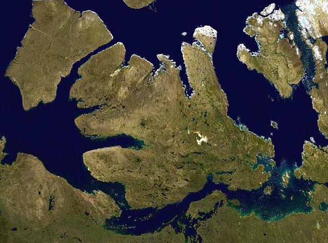
Victoria Island in the Canadian arctic.
NASA blue pearl data, collecter using NASA World Wind.
| Cette image est dans le domaine public car elle est constituée d'une capture d'écran du logiciel World Wind de la NASA qui utilise des données du domaine public, comme Blue Marble, MODIS, Landsat, SRTM, USGS ou GLOBE.
|
 |
Amazray n ufaylu
Senned ɣef yiwen azmez d usrag iwakken ad ẓṛeḍ afaylu aken yella deg imir nni.
| Azemz/Ssaɛa | Aqmamaḍ | Iseggiwen | Amseqdac | Awennit | |
|---|---|---|---|---|---|
| Lux a | 9 Yebrir 2006 à 15:28 | | 1 280 × 948 (198 KB/KO) | Finlay McWalter | Victoria Island in the Canadian arctic. NASA blue pearl data, collecter using NASA World Wind. {{PD-USGov-NASA}} Category:Nunavut Category:Satellite images of islands Category:Satellite pictures of Canada |
Aseqdec n ufaylu
Asebter agi teseqdac afaylu agi :
Aseqdec n ufaylu amatu
Iwikiyen-agi-nniḍen seqdacen afaylu-agi:
- Aseqdec ɣef af.wikipedia.org
- Aseqdec ɣef ar.wikipedia.org
- Aseqdec ɣef arz.wikipedia.org
- Aseqdec ɣef ast.wikipedia.org
- Aseqdec ɣef az.wikipedia.org
- Aseqdec ɣef bat-smg.wikipedia.org
- Aseqdec ɣef ba.wikipedia.org
- Aseqdec ɣef be-tarask.wikipedia.org
- Aseqdec ɣef be.wikipedia.org
- Aseqdec ɣef bg.wikipedia.org
- Aseqdec ɣef ca.wikipedia.org
- Aseqdec ɣef ceb.wikipedia.org
- Aseqdec ɣef cs.wikipedia.org
- Aseqdec ɣef cy.wikipedia.org
- Aseqdec ɣef de.wikipedia.org
- Aseqdec ɣef el.wikipedia.org
- Aseqdec ɣef en.wikipedia.org
- Aseqdec ɣef en.wikiversity.org
- Aseqdec ɣef eo.wikipedia.org
- Aseqdec ɣef es.wikipedia.org
- Aseqdec ɣef et.wikipedia.org
- Aseqdec ɣef eu.wikipedia.org
- Aseqdec ɣef fa.wikipedia.org
- Aseqdec ɣef fi.wikipedia.org
- Aseqdec ɣef frr.wikipedia.org
- Aseqdec ɣef fr.wikipedia.org
- Aseqdec ɣef fr.wikivoyage.org
Wali l’utilisation globale n ufaylu-agi.