
Tugna:São Tomé and Príncipe location map.svg

Taille de cet aperçu PNG pour ce fichier SVG : 428 × 599 iferdisen n tugna. Tibuda nniḍen : 171 × 240 iferdisen n tugna | 343 × 480 iferdisen n tugna | 549 × 768 iferdisen n tugna | 732 × 1 024 iferdisen n tugna | 1 464 × 2 048 iferdisen n tugna | 496 × 694 iferdisen n tugna.
Afaylu aneṣli (Afaylu SVG, tabadut n 496 × 694 pixel, lqedd : 10 KB/KO)
Agzul
| Aglam |
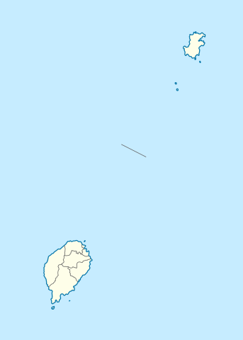
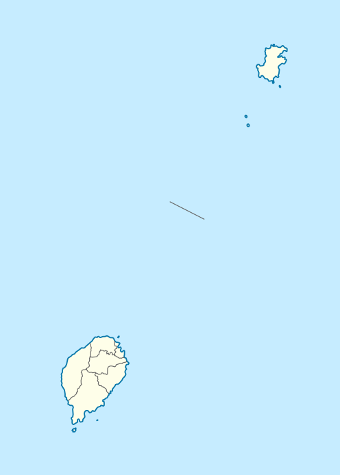
Deutsch: Positionskarte von São Tomé and Príncipe
Quadratische Plattkarte. Geographische Begrenzung der Karte:
English: Location map of São Tomé and Príncipe
Equirectangular projection. Geographic limits of the map:
|
| Azemz | |
| Aɣbalu |
Amahil udmawan, using
|
| Ameskar | NordNordWest |
| Tasiregt (Tulsa n useqdec n ufaylu-agi) |
Moi, en tant que détenteur des droits d’auteur sur cette œuvre, je la publie sous la licence suivante : Afaylu-agi yella ddaw n tewtilin n turagt Creative Commons Attribution-Share Alike 3.0 Unported.
|

|
Cette carte a été créée ou améliorée dans le Kartenwerkstatt (Atelier cartographique allemand). Vous pouvez également y proposer des cartes à améliorer.
|
Amazray n ufaylu
Senned ɣef yiwen azmez d usrag iwakken ad ẓṛeḍ afaylu aken yella deg imir nni.
| Azemz/Ssaɛa | Aqmamaḍ | Iseggiwen | Amseqdac | Awennit | |
|---|---|---|---|---|---|
| Lux a | 27 Wamber 2020 à 19:01 | | 496 × 694 (10 KB/KO) | NordNordWest | more exact |
| 17 Yunyu 2014 à 15:25 |  | 496 × 694 (9 KB/KO) | NordNordWest | corr | |
| 5 Tuber 2009 à 19:40 |  | 496 × 694 (13 KB/KO) | NordNordWest | {{int:filedesc}} {{Information |Description= {{de|Positionskarte von São Tomé and Príncipe}} Quadratische Plattkarte. Geographische Begrenzung der Karte: * N: 1.9° N * S: 0.2° S * W: 6.2° E * O: 7.7° E {{en|Location |
Aseqdec n ufaylu
Ulaḥedd seg isebtar sɛan azday ar afaylu-agi.
Aseqdec n ufaylu amatu
Iwikiyen-agi-nniḍen seqdacen afaylu-agi:
- Aseqdec ɣef af.wikipedia.org
- Aseqdec ɣef am.wikipedia.org
- Aseqdec ɣef an.wikipedia.org
- Aseqdec ɣef ar.wikipedia.org
- Aseqdec ɣef ast.wikipedia.org
- Aseqdec ɣef ba.wikipedia.org
- Aseqdec ɣef be-tarask.wikipedia.org
- Aseqdec ɣef be.wikipedia.org
- Aseqdec ɣef bg.wikipedia.org
- Aseqdec ɣef bn.wikipedia.org
- Aseqdec ɣef bs.wikipedia.org
- Aseqdec ɣef ca.wikipedia.org
- Aseqdec ɣef ceb.wikipedia.org
Wali l’utilisation globale n ufaylu-agi.