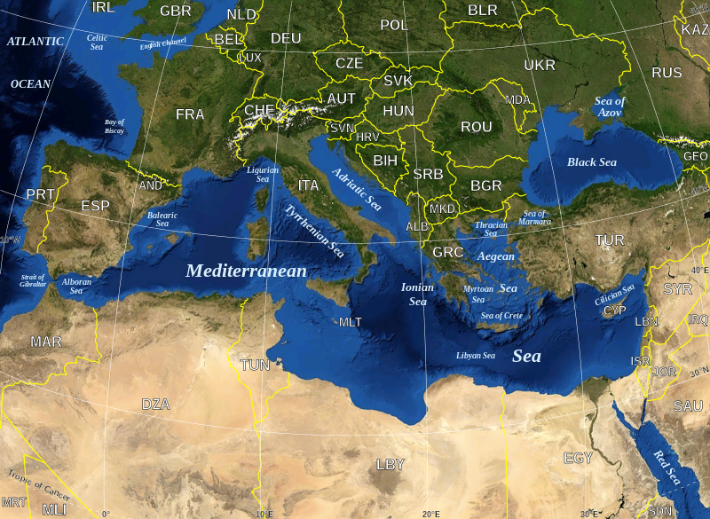
Tugna:Mediterranean Sea political map-en.svg

Taille de cet aperçu PNG pour ce fichier SVG : 800 × 585 iferdisen n tugna. Tibuda nniḍen : 320 × 234 iferdisen n tugna | 640 × 468 iferdisen n tugna | 1 024 × 749 iferdisen n tugna | 1 280 × 936 iferdisen n tugna | 2 560 × 1 872 iferdisen n tugna | 2 046 × 1 496 iferdisen n tugna.
Afaylu aneṣli (Afaylu SVG, tabadut n 2 046 × 1 496 pixel, lqedd : 1,11 MB/MO)
Amazray n ufaylu
Senned ɣef yiwen azmez d usrag iwakken ad ẓṛeḍ afaylu aken yella deg imir nni.
| Azemz/Ssaɛa | Aqmamaḍ | Iseggiwen | Amseqdac | Awennit | |
|---|---|---|---|---|---|
| Lux a | 4 Meɣres 2020 à 16:07 |  | 2 046 × 1 496 (1,11 MB/MO) | Ifwest | File uploaded using svgtranslate tool (https://tools.wmflabs.org/svgtranslate/). Added translation for fallback. |
| 19 Mayyu 2008 à 16:18 |  | 2 046 × 1 496 (1,1 MB/MO) | Sting | "Tropic of Cancer" label correction | |
| 21 Yunyu 2007 à 01:01 |  | 2 046 × 1 496 (1,1 MB/MO) | Sting | {{Information |Description=Map in English of the Mediterranean Sea, with the borders and the name of the States following the ISO 3166-1 Alpha-3 code. |Source=Own work ;<br/>Background map : screenshot from NASA World Wind (Publi |
Aseqdec n ufaylu
Asebter agi teseqdac afaylu agi :
Aseqdec n ufaylu amatu
Iwikiyen-agi-nniḍen seqdacen afaylu-agi:
- Aseqdec ɣef ab.wikipedia.org
- Aseqdec ɣef arz.wikipedia.org
- Aseqdec ɣef ast.wikipedia.org
- Aseqdec ɣef ba.wikipedia.org
- Aseqdec ɣef bcl.wikipedia.org
- Aseqdec ɣef be-tarask.wikipedia.org
- Aseqdec ɣef bn.wikipedia.org
- Aseqdec ɣef br.wikipedia.org
- Aseqdec ɣef ca.wikipedia.org
- Llista de topònims d'Alcanar
- Llista de topònims d'Amposta
- Llista de topònims de la Ràpita
- Llista de topònims de Sant Jaume d'Enveja
- Llista de topònims d'Altafulla
- Llista de topònims de Creixell
- Llista de topònims de Roda de Berà
- Llista de topònims de Tarragona
- Llista de topònims de Torredembarra
- Llista de topònims de Calafell
- Llista de topònims de Cunit
- Llista de topònims del Vendrell
- Llista de topònims de Cubelles
- Llista de topònims de Sitges
- Llista de topònims de Vilanova i la Geltrú
- Llista de topònims de Begur
- Llista de topònims de Calonge i Sant Antoni
- Llista de topònims de Castell d'Aro, Platja d'Aro i s'Agaró
- Llista de topònims de Palamós
- Llista de topònims de Pals
- Llista de topònims de Sant Feliu de Guíxols
- Llista de topònims de Tossa de Mar
- Llista de topònims d'Arenys de Mar
- Llista de topònims de Cabrera de Mar
- Llista de topònims de Caldes d'Estrac
- Llista de topònims de Calella
- Llista de topònims de Canet de Mar
- Llista de topònims de Malgrat de Mar
- Llista de topònims de Mataró
- Llista de topònims de Montgat
- Llista de topònims de Pineda de Mar
- Llista de topònims de Sant Andreu de Llavaneres
- Llista de topònims de Sant Vicenç de Montalt
- Llista de topònims de Vilassar de Mar
- Llista de topònims del Prat de Llobregat
- Llista de topònims de Sant Adrià de Besòs
- Llista de topònims del districte de Sant Martí
- Llista de topònims de Sants-Montjuïc
- Aseqdec ɣef ca.wikiquote.org
Wali l’utilisation globale n ufaylu-agi.


