
Tugna:Indian Subcontinent (orthographic projection).png
Tiddi n azaraskan agi : 600 × 600 iferdisen n tugna. Tibuda nniḍen : 240 × 240 iferdisen n tugna | 480 × 480 iferdisen n tugna | 768 × 768 iferdisen n tugna | 1 024 × 1 024 iferdisen n tugna | 1 443 × 1 443 iferdisen n tugna.
Afaylu aneṣli (1 443 × 1 443 pixel, tiddi n ufaylu: 529 KB/KO, anaw n MIME: image/png)
Agzul
| Aglam |
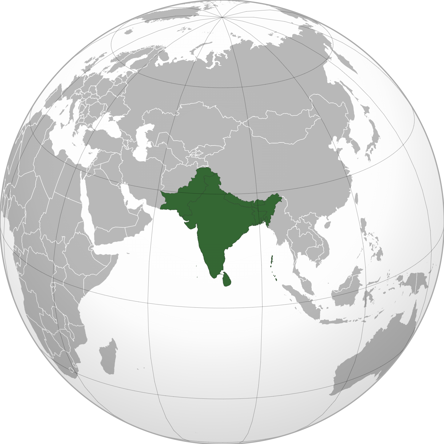
English: Grey-green orthographic projection focused on the Indian Subcontinent, where all countries part of said Indian Subcontinent are highlighted dark green to provide the viewer with a visual representation of where the Indian Subcontinent is and what countries are part of it. |
||
| Azemz | |||
| Aɣbalu | |||
| Ameskar | Zeex.rice | ||
| Autres versions |
.svg) |
||
| PNG information |
|
.svg)
.svg)
.svg)
.svg)
.svg)
.svg)
.svg)
.svg)
.svg)
.svg)
.svg)
.svg)
.svg)
.svg)
.svg)
.svg)
.svg)
.svg)
.svg)
.svg)
.svg)
.svg)
.svg)
.svg)
.svg)
.svg)
.svg)
.svg)
.svg)
.svg)
.svg)
.svg)
.svg)
.svg)
.svg)
.svg)
.svg)
.svg)
.svg)
.svg)
.svg)
.svg)
.svg)
.svg)
.svg)
.svg)
.svg)
.svg)
.svg)
.svg)
.svg)
.svg)
.svg)
.svg)
.svg)
.svg)
.svg)
.svg)
.svg)
.svg)
.svg)
.svg)
.svg)
.svg)
.svg)
.svg)
.svg)
.svg)
.svg)
.svg)
.svg)
.svg)
.svg)

.svg)

.svg)

.svg)
.svg)
.svg)
.svg)
.svg)
.svg)
.svg)


.svg)
.svg)
.svg)
.svg)
.svg)
.svg)
.svg)

.svg)
.svg)
.svg)
.svg)
.svg)
.svg)
.svg)
.svg)
.svg)

.svg)
.svg)
.svg)
.svg)
.svg)
.svg)
.svg)
_without_national_boundaries.svg)
.svg)
.svg)
.svg)
.svg)
.svg)
.svg)

.svg)
.svg)
.png)
.svg)
.svg)
.svg)
.svg)

.svg)
.svg)
.svg)
.svg)
.svg)
.svg)
.svg)
.svg)
.svg)
.svg)
.svg)

.svg)
.svg)
.svg)
.svg)
.svg)
.svg)
.svg)
.svg)
.svg)

.svg)
.svg)

.svg)
.svg)
.svg)
.svg)
.svg)
.svg)
.svg)
.svg)
.svg)
.svg)
.svg)
.svg)
.svg)
.svg)
.svg)
.svg)
.svg)
.svg)
.svg)
.svg)
.svg)
.svg)
.svg)
.svg)
.svg)
.svg)
.svg)
_-_Crimea_disputed.svg)
.svg)
.svg)
.svg)
.svg)
.svg)
.svg)
.svg)
.svg)
.svg)
.svg)
.svg)
_political.svg)
.svg)
.svg)
.svg)
.svg)
_-_Crimea_disputed_-_no_borders.svg)
.svg)
.svg)
.svg)
.svg)
.svg)
.svg)
.svg)
.svg)
.svg)
.svg)
.svg)

.svg)
.svg)
.svg)

.png)
.svg)
.svg)
.svg)
.svg)
.svg)
.svg)
.svg)
.svg)
.svg)
.svg)
.svg)
.svg)
.svg)
.svg)
.svg)
.svg)
.svg)
.svg)
.svg)
.svg)
.svg)
.svg)
.svg)
.svg)
.svg)
.svg)
.svg)
.svg)
.svg)
.svg)
.svg)
.svg)
.svg)
.svg)
.png)
.svg)
.svg)
.svg)
_(orthographic_projection).png)
.png)
Turagt
Moi, en tant que détenteur des droits d’auteur sur cette œuvre, je la publie sous les licences suivantes :
Afaylu-agi yella ddaw n tewtilin n turagt Creative Commons Attribution-Share Alike 3.0 Unported.
- Ɣuṛ-k tilelli:
- i beṭṭu – akken ad tneɣleḍ, ad tzuzreḍ neɣ ad tebḍuḍ amahil-agi
- i uṣeggem – i uṣeggem n umahil
- Ddaw n tiwtilin-agi:
- bab – Yessefk ad d-bedreḍ isem n umeskar aneṣli s wudem yettwammlen sɣuṛ ameskar n umahil neɣ bab n izerfan i k-imudden tasiregt (mačči s wudem yemmalen am akken yettmuddu-yak afus neɣ yeqbel aseqdec-it n umahil).
- bḍut akken yella – Ma tbeddleḍ, teskelteḍ, neɣ tebniḍ ɣef umahil-agi, yessefk ad tezzuzreḍ amahil i d-yeffɣen ɣas ddaw n turagt-nni neɣ turagt icuban ɣuṛ-s.

|
Ɣuṛ-k tasiregt akken ad tneɣleḍ, ad tzuzreḍ neɣ ad tesnifleḍ isemli-agi akken yella di tewtilin n GNU Free Documentation License lqem 1.2 neq yal lqem amaynut i d-yeffɣen sɣuṛ Free Software Foundation, s war abeddel di tgezmiyin, s war aḍris deg usebter amenzu n tdulineɣ s war aḍris deg usebter aneggaru n tduli. Amedya n turagt yedda deg tgezmi ittusemman GNU Free Documentation License. |
|
|
Ɣuṛ-k tasiregt akken ad tneɣleḍ, ad tzuzreḍ neɣ ad tesnifleḍ isemli-agi akken yella di tewtilin n GNU Free Documentation License lqem 1.2 neq yal lqem amaynut i d-yeffɣen sɣuṛ Free Software Foundation, s war abeddel di tgezmiyin, s war aḍris deg usebter amenzu n tdulineɣ s war aḍris deg usebter aneggaru n tduli. Amedya n turagt yedda deg tgezmi ittusemman GNU Free Documentation License. |
Tzemreḍ ad ferneḍ yiwet seg turagin-agi.
Cette carte a été créée avec le Generic Mapping Tools : https://www.generic-mapping-tools.org/ utilisant pour le relief un ou plusieurs de ces jeux de données du domaine public :
|
|
|
Ɣuṛ-k tasiregt akken ad tneɣleḍ, ad tzuzreḍ neɣ ad tesnifleḍ isemli-agi akken yella di tewtilin n GNU Free Documentation License lqem 1.2 neq yal lqem amaynut i d-yeffɣen sɣuṛ Free Software Foundation, s war abeddel di tgezmiyin, s war aḍris deg usebter amenzu n tdulineɣ s war aḍris deg usebter aneggaru n tduli. Amedya n turagt yedda deg tgezmi ittusemman GNU Free Documentation License. |
Amazray n ufaylu
Senned ɣef yiwen azmez d usrag iwakken ad ẓṛeḍ afaylu aken yella deg imir nni.
| Azemz/Ssaɛa | Aqmamaḍ | Iseggiwen | Amseqdac | Awennit | |
|---|---|---|---|---|---|
| Lux a | 10 Wamber 2022 à 17:29 | | 1 443 × 1 443 (529 KB/KO) | Sourav Bapuli | Added border for South Sudan as requested by {{u|Maphobbyist}} |
| 3 Tuber 2020 à 06:59 |  | 551 × 551 (143 KB/KO) | Zeex.rice | Uploaded a work by https://commons.wikimedia.org/wiki/User:Serg!o from https://en.wikipedia.org/wiki/File:South_Asia_(orthographic_projection)_without_national_boundaries.svg with UploadWizard |
Aseqdec n ufaylu
Ulaḥedd seg isebtar sɛan azday ar afaylu-agi.
Aseqdec n ufaylu amatu
Iwikiyen-agi-nniḍen seqdacen afaylu-agi:
- Aseqdec ɣef en.wikipedia.org
- Aseqdec ɣef ur.wikipedia.org
.png)