
Tugna:Hennepin County Minnesota Incorporated and Unincorporated areas Minneapolis Highlighted.svg

Taille de cet aperçu PNG pour ce fichier SVG : 800 × 485 iferdisen n tugna. Tibuda nniḍen : 320 × 194 iferdisen n tugna | 640 × 388 iferdisen n tugna | 1 024 × 621 iferdisen n tugna | 1 280 × 776 iferdisen n tugna | 2 560 × 1 552 iferdisen n tugna | 1 310 × 794 iferdisen n tugna.
Afaylu aneṣli (Afaylu SVG, tabadut n 1 310 × 794 pixel, lqedd : 1,19 MB/MO)
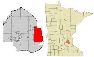
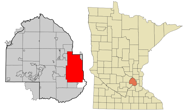
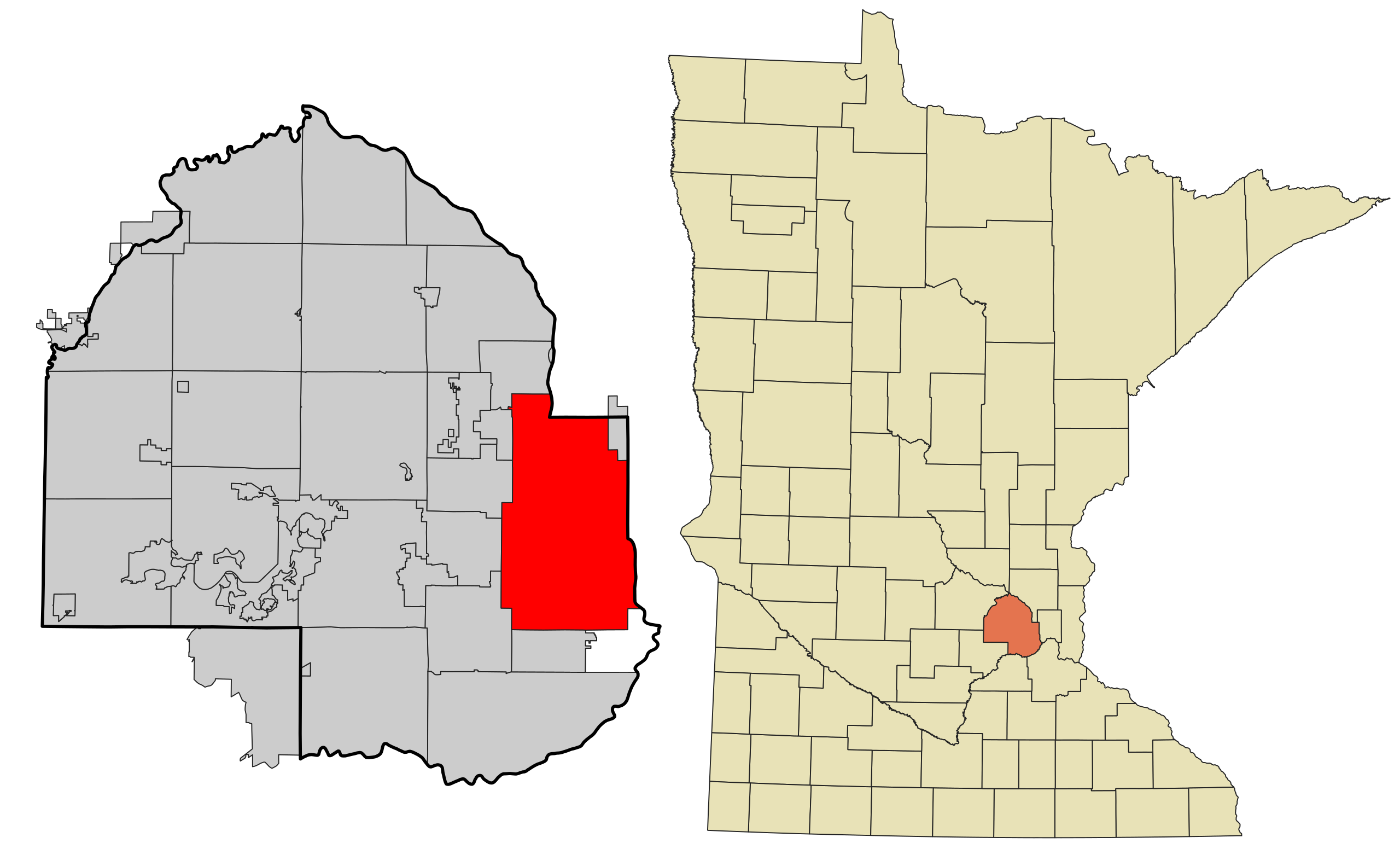
| Aglam | This map shows the incorporated and unincorporated areas in Hennepin County, Minnesota, highlighting Minneapolis in red. It was created with a custom script with US Census Bureau data and modified with Inkscape. |
| Azemz | |
| Aɣbalu | My own work, based on public domain information. Based on similar map concepts by Ixnayonthetimmay |
| Ameskar | Arkyan |
| SVG information | Le code de ce fichier SVG n'est pas valide en raison de 34 erreurs. |
Moi, en tant que détenteur des droits d’auteur sur cette œuvre, je la publie sous les licences suivantes :

|
Ɣuṛ-k tasiregt akken ad tneɣleḍ, ad tzuzreḍ neɣ ad tesnifleḍ isemli-agi akken yella di tewtilin n GNU Free Documentation License lqem 1.2 neq yal lqem amaynut i d-yeffɣen sɣuṛ Free Software Foundation, s war abeddel di tgezmiyin, s war aḍris deg usebter amenzu n tdulineɣ s war aḍris deg usebter aneggaru n tduli. Amedya n turagt yedda deg tgezmi ittusemman GNU Free Documentation License. |
| Afaylu-agi yella ddaw n tewtilin n turagt Creative Commons Attribution-Share Alike 3.0 Unported. | ||
| ||
| Ce bandeau de licence a été ajouté à ce fichier dans le cadre de la procédure de mise à jour des licences des images sous GFDL. |
Ce fichier est sous licence Creative Commons Attribution – Partage dans les Mêmes Conditions 2.5 Générique, 2.0 Générique et 1.0 Générique.
- Ɣuṛ-k tilelli:
- i beṭṭu – akken ad tneɣleḍ, ad tzuzreḍ neɣ ad tebḍuḍ amahil-agi
- i uṣeggem – i uṣeggem n umahil
- Ddaw n tiwtilin-agi:
- bab – Yessefk ad d-bedreḍ isem n umeskar aneṣli s wudem yettwammlen sɣuṛ ameskar n umahil neɣ bab n izerfan i k-imudden tasiregt (mačči s wudem yemmalen am akken yettmuddu-yak afus neɣ yeqbel aseqdec-it n umahil).
- bḍut akken yella – Ma tbeddleḍ, teskelteḍ, neɣ tebniḍ ɣef umahil-agi, yessefk ad tezzuzreḍ amahil i d-yeffɣen ɣas ddaw n turagt-nni neɣ turagt icuban ɣuṛ-s.
Tzemreḍ ad ferneḍ yiwet seg turagin-agi.
Amazray n ufaylu
Senned ɣef yiwen azmez d usrag iwakken ad ẓṛeḍ afaylu aken yella deg imir nni.
| Azemz/Ssaɛa | Aqmamaḍ | Iseggiwen | Amseqdac | Awennit | |
|---|---|---|---|---|---|
| Lux a | 3 Fuṛaṛ 2021 à 01:18 | | 1 310 × 794 (1,19 MB/MO) | SpeedMcCool | update for 2021 |
| 17 Tuber 2007 à 19:01 |  | 850 × 550 (205 KB/KO) | ArkyBot~commonswiki | {{Information |Description=This map shows the incorporated and unincorporated areas in Hennepin County, Minnesota, highlighting Minneapolis in red. |
Aseqdec n ufaylu
Asebter agi teseqdac afaylu agi :
Aseqdec n ufaylu amatu
Iwikiyen-agi-nniḍen seqdacen afaylu-agi:
- Aseqdec ɣef af.wikipedia.org
- Aseqdec ɣef ang.wikipedia.org
- Aseqdec ɣef ar.wikipedia.org
- Aseqdec ɣef arz.wikipedia.org
- Aseqdec ɣef ast.wikipedia.org
- Aseqdec ɣef azb.wikipedia.org
- Aseqdec ɣef bn.wikipedia.org
- Aseqdec ɣef br.wikipedia.org
- Aseqdec ɣef ca.wikipedia.org
- Aseqdec ɣef de.wikipedia.org
- Aseqdec ɣef el.wikipedia.org
- Aseqdec ɣef en.wikipedia.org
- Aseqdec ɣef eo.wikipedia.org
- Aseqdec ɣef es.wikipedia.org
- Aseqdec ɣef eu.wikipedia.org
- Aseqdec ɣef fa.wikipedia.org
- Aseqdec ɣef fi.wikipedia.org
- Aseqdec ɣef fo.wikipedia.org
- Aseqdec ɣef fr.wikipedia.org
- Aseqdec ɣef fr.wikinews.org
- Aseqdec ɣef fy.wikipedia.org
- Aseqdec ɣef ga.wikipedia.org
- Aseqdec ɣef gd.wikipedia.org
- Aseqdec ɣef gl.wikipedia.org
- Aseqdec ɣef gu.wikipedia.org
- Aseqdec ɣef he.wikipedia.org
- Aseqdec ɣef ht.wikipedia.org
- Aseqdec ɣef hu.wikipedia.org
- Aseqdec ɣef hy.wikipedia.org
- Aseqdec ɣef ia.wikipedia.org
- Aseqdec ɣef id.wikipedia.org
- Aseqdec ɣef incubator.wikimedia.org
- Aseqdec ɣef it.wikipedia.org
- Aseqdec ɣef ja.wikipedia.org
- Aseqdec ɣef kn.wikipedia.org
- Aseqdec ɣef ku.wikipedia.org
- Aseqdec ɣef kw.wikipedia.org
- Aseqdec ɣef la.wikipedia.org
- Aseqdec ɣef ln.wikipedia.org
- Aseqdec ɣef lv.wikipedia.org
Wali l’utilisation globale n ufaylu-agi.