
Tugna:Bristol UK locator map 2010.svg

Taille de cet aperçu PNG pour ce fichier SVG : 494 × 600 iferdisen n tugna. Tibuda nniḍen : 198 × 240 iferdisen n tugna | 395 × 480 iferdisen n tugna | 633 × 768 iferdisen n tugna | 843 × 1 024 iferdisen n tugna | 1 687 × 2 048 iferdisen n tugna | 1 108 × 1 345 iferdisen n tugna.
Afaylu aneṣli (Afaylu SVG, tabadut n 1 108 × 1 345 pixel, lqedd : 302 KB/KO)
Agzul
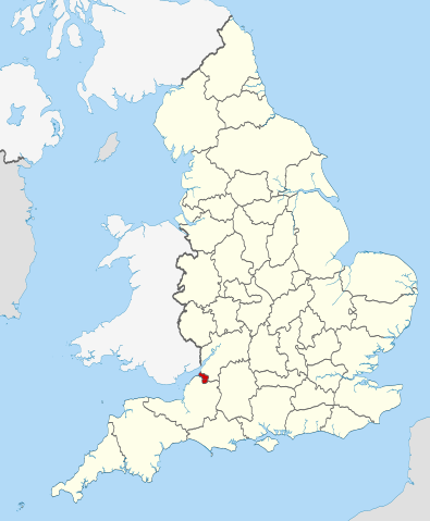
| Aglam | Location of the ceremonial county of Bristol within England. |
| Azemz | |
| Aɣbalu |
National Geospatial-Intelligence Agency
|
| Ameskar | Nilfanion |
Turagt
Moi, en tant que détenteur des droits d’auteur sur cette œuvre, je la publie sous les licences suivantes :
Afaylu-agi yella ddaw n tewtilin n turagt Creative Commons Attribution-Share Alike 3.0 Unported.
- Ɣuṛ-k tilelli:
- i beṭṭu – akken ad tneɣleḍ, ad tzuzreḍ neɣ ad tebḍuḍ amahil-agi
- i uṣeggem – i uṣeggem n umahil
- Ddaw n tiwtilin-agi:
- bab – Yessefk ad d-bedreḍ isem n umeskar aneṣli s wudem yettwammlen sɣuṛ ameskar n umahil neɣ bab n izerfan i k-imudden tasiregt (mačči s wudem yemmalen am akken yettmuddu-yak afus neɣ yeqbel aseqdec-it n umahil).
- bḍut akken yella – Ma tbeddleḍ, teskelteḍ, neɣ tebniḍ ɣef umahil-agi, yessefk ad tezzuzreḍ amahil i d-yeffɣen ɣas ddaw n turagt-nni neɣ turagt icuban ɣuṛ-s.

|
Ɣuṛ-k tasiregt akken ad tneɣleḍ, ad tzuzreḍ neɣ ad tesnifleḍ isemli-agi akken yella di tewtilin n GNU Free Documentation License lqem 1.2 neq yal lqem amaynut i d-yeffɣen sɣuṛ Free Software Foundation, s war abeddel di tgezmiyin, s war aḍris deg usebter amenzu n tdulineɣ s war aḍris deg usebter aneggaru n tduli. Amedya n turagt yedda deg tgezmi ittusemman GNU Free Documentation License. |
Tzemreḍ ad ferneḍ yiwet seg turagin-agi.

|
This is one of the images forming part of the Valued image set: Locator maps of the Ceremonial counties of England on Wikimedia Commons. The image set has been assessed under the valued image set criteria and is considered the most valued set on Commons within the scope:
Locator maps of the Ceremonial counties of England
You can see its nomination at Commons:Valued image candidates/Locator maps of English ceremonial counties. |
Amazray n ufaylu
Senned ɣef yiwen azmez d usrag iwakken ad ẓṛeḍ afaylu aken yella deg imir nni.
| Azemz/Ssaɛa | Aqmamaḍ | Iseggiwen | Amseqdac | Awennit | |
|---|---|---|---|---|---|
| Lux a | 23 Wamber 2010 à 22:30 | | 1 108 × 1 345 (302 KB/KO) | Nilfanion | == Summary == {{Information |Description=Location of the ceremonial county of Bristol within England. |Source=Ordnance Survey [https://www.ordnancesurvey.co.uk/opendatadownload/products.html OpenData]: *County boundarie |
Aseqdec n ufaylu
Asebter agi teseqdac afaylu agi :
Aseqdec n ufaylu amatu
Iwikiyen-agi-nniḍen seqdacen afaylu-agi:
- Aseqdec ɣef ar.wikipedia.org
- Aseqdec ɣef arz.wikipedia.org
- Aseqdec ɣef ast.wikipedia.org
- Aseqdec ɣef bg.wikipedia.org
- Aseqdec ɣef ca.wikipedia.org
- Aseqdec ɣef cs.wikipedia.org
- Aseqdec ɣef de.wikipedia.org
- Aseqdec ɣef diq.wikipedia.org
- Aseqdec ɣef el.wikipedia.org
- Aseqdec ɣef en.wikipedia.org
- Snuff Mills
- Knowle, Bristol
- The Chessels
- Lawrence Weston, Bristol
- Template:Bristol-geo-stub
- Stoke Lodge
- Sneyd Park
- Golden Hill, Bristol
- Monks Park
- Windmill Hill, Bristol
- Bristol Central (UK Parliament constituency)
- Hengrove
- Speedwell, Bristol
- Westbury Park, Bristol
- Bullock's Park
- Ashton Vale
- Hillfields, Bristol
- Kingsdown, Bristol
- Trinity Road Police Station
- Former Bank of England, Bristol
- Old Post Office, Bristol
- Quakers Friars
- St Nicholas' Almshouses
- Mauretania, Bristol
- Kings Weston Hill
- Foster's Almshouses, Bristol
- Merchant Hall
- Bristol Marina
- Silicon Gorge
- Clifton East (former ward)
- Whitchurch Park (ward)
- Filwood (ward)
- St George East
- Northern Stormwater Interceptor, Bristol
- Ashton Gate, Bristol
- Millennium Square, Bristol
- Great Stoke
- Begbrook
- Purdown
- User:Dr. Blofeld/April 2011
Wali l’utilisation globale n ufaylu-agi.